 Filter: Categories of Wisconsin Historical Images
Filter: FULL_DATE of 1830
Filter: Categories of Wisconsin Historical Images
Filter: FULL_DATE of 1830
| Date: | 1830 |
|---|---|
| Description: | An illustration from the book Das Illustrirte Mississippithal of the Battle of Bad Axe being fought on the river. |

| Date: | 1830 |
|---|---|
| Description: | Illustration of Fort Crawford. Caption reads: "Fort Crawford in 1830, Prairie Du Chien, Wis." |

| Date: | 1830 |
|---|---|
| Description: | Multicolor map illustrates the development of states and territories in the Old Northwest. Wisconsin was on the frontier of settlement when this map was pu... |

| Date: | 1830 |
|---|---|
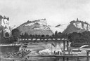
| Description: | Fort Winnebago from an original drawing by Jefferson Davis. |

| Date: | 1830 |
|---|---|
| Description: | A color map of the Michigan and Wisconsin territories with an inset showing the Ste. Marie River. |

| Date: | 1830 |
|---|---|
| Description: | Drawing of the Astor building. Caption reads: "Astor Building in 1830 Main Village Lot Prairie•du•Chien". |

| Date: | 1830 |
|---|---|
| Description: | Portrait of Dr. William Beaumont who conducted some of his famous experiments on human digestion while posted at Fort Crawford in Prairie du Chien in 1830.... |

| Date: | 1830 |
|---|---|
| Description: | An ink on paper, hand-drawn map, showing the wagons roads that travel through Lafayette County, traveling between Galena, Illinois, and Mineral Point, Wisc... |

| Date: | 1830 |
|---|---|
| Description: | A hand-drawn map of the township sectioning of Milwaukee, eastern Waukesha, northern Walworth, and Racine Counties. Other items shown in the map are the la... |

| Date: | 1830 |
|---|---|
| Description: | An ink on paper, hand-drawn map of the town of Milwaukee, showing the divisions and landownership within the town by private individuals as well as those l... |

| Date: | 1830 |
|---|---|
| Description: | This early 19th century manuscript map of Prairie du Chien, Wisconsin, shows sections, landownership and acreages, roads, and ferries in the towns of Bridg... |

| Date: | 1830 |
|---|---|
| Description: | Plat map showing lots and streets. A few lots are marked with names, including: Boyd, Newton, Williams, Baird, Suydam, etc. |

| Date: | 1830 |
|---|---|
| Description: | This map is ink, color, and pencil on paper and shows streets, farm lots, and a church. Handwritten notes are at the bottom of the map and are very light. |
| Date: | 1830 |
|---|---|
| Description: | This plat map is pen-and-ink on tracing paper and shows a paper city planned in the late 1830's located on the shore of Swan Lake, Columbia County, Wiscons... |

| Date: | 1830 |
|---|---|
| Description: | This map shows rivers, lakes, and landmarks in the territories of Michigan and Ouisconsin. Includes an inserted map showing part of the Ste. Marie River an... |
If you didn't find the material you searched for, our Library Reference Staff can help.
Call our reference desk at 608-264-6535 or email us at:
